Finding the Right Sector and Aiming the Antenna
Rank the sectors that cover an address, check the terrain line of sight along each path, aim the CPE from the phone, and save the result on the service.
Wireless installs go wrong for two boring reasons: the dish ends up pointed at the wrong tower, or at the right tower through a hill. This article shows how ISPbox answers both questions before anyone climbs a ladder - which sector actually covers the address, whether the terrain leaves the path clear, and where exactly to point the antenna.
What you need on the map first
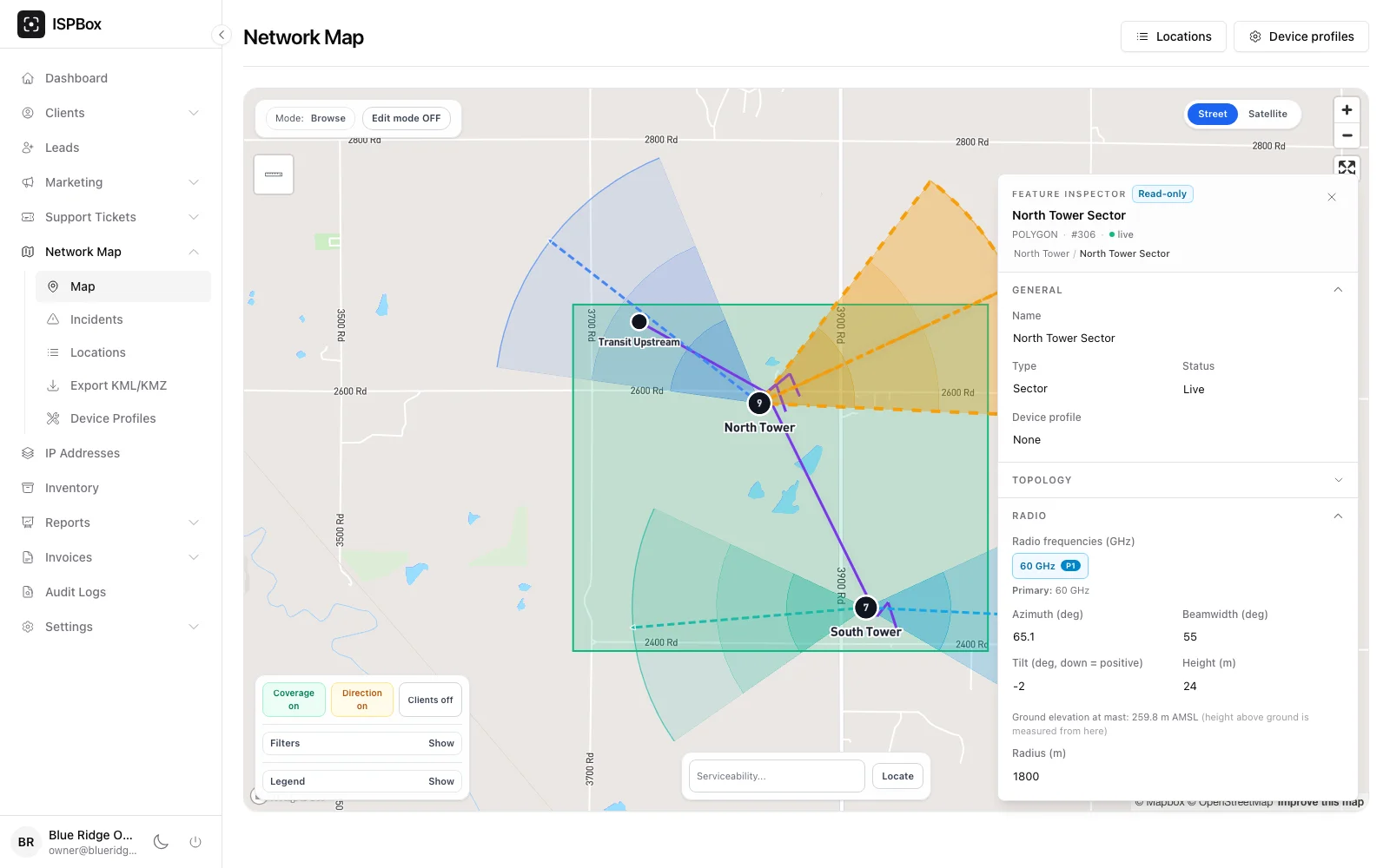
Everything here is built from the wireless sectors you draw under Network > Map. A sector is a polygon with engineering properties, and those properties are what the field app reads:
- Azimuth - the direction the sector faces, in degrees from north.
- Beamwidth - how wide the beam is. Together with the azimuth it decides whether an address is "in beam".
- Tilt - the mechanical downtilt. Positive means the antenna points down.
- Height - the antenna height above the ground at the mast, not above sea level.
- Radius - how far you expect the sector to serve.
- Radio frequencies - the first one is used for the Fresnel zone calculation.
Under the height field ISPbox shows the ground elevation at the mast, read from terrain data, so there is no confusion between the two heights. In the screenshot below the mast antenna sits 24 m above a ground level of 259.8 m above sea level.
If a sector has no azimuth or height set, the field app falls back to defaults (30 degrees of beamwidth, 10 m of antenna height, 2 km of range). Fill the real numbers in once and every install after that gets better answers.
Finding the sector from the field app
In the ISPbox Field app there are three ways into the sector finder:
- Network > Map > Nearest sectors - uses a fresh GPS fix from the phone.
- Client > service card > Find sector - uses the install coordinates saved on the service, or the client address position.
- Tapping a sector on the map - opens the sector card, with the option to align that antenna on the mast.
The screen starts with the position it used and a CPE antenna height above ground field. That height matters: it is one end of the line-of-sight calculation. Leave it empty and ISPbox assumes 5 m, which the caption under the field always states.
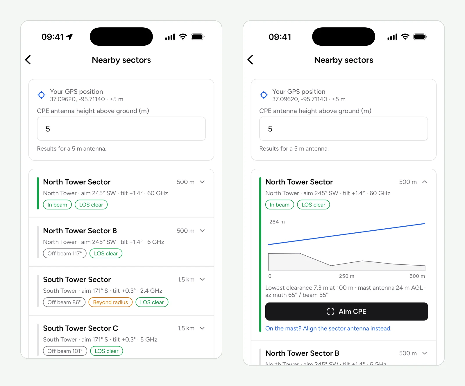
Sectors are ranked, not just listed by distance. Sectors that cover the position and have a clear path come first, then covering sectors with a marginal path, then the rest. Each row tells you:
- the distance to the mast and the bearing to aim at (for example "aim 245° SW");
- the elevation angle from the CPE up to the mast antenna, already corrected for both antenna heights and earth curvature;
- In beam or Off beam with the angle by which the address misses the beam;
- Beyond radius when the address is further out than the sector range;
- the line-of-sight verdict, and the frequency.
Reading the terrain profile
Tap a row to open the profile. The grey shape is the ground along the path, the blue line is the radio path between the two antennas, and the caption gives the lowest clearance and where along the path it sits.
The verdict has four states:
- LOS clear - the path stays above the ground and outside 60% of the first Fresnel zone.
- LOS marginal - nothing blocks the path, but the ground eats into the Fresnel zone. The link may work and may be unstable in rain or wind.
- LOS blocked - the terrain crosses the path. The lowest clearance is shown as a negative number and the obstruction is marked on the chart.
- LOS unknown - no terrain data was available for that path. Elevation angles then assume flat ground, and the screen says so.
Raising the CPE height and refreshing is a fair way to answer "would a 3 m mast on the roof fix this?" - a blocked path often turns clear a few metres higher.
Aiming the antenna
From an expanded row, Aim CPE opens the aiming view for the subscriber end: the target bearing and elevation come from that row. From a sector card on the map, Align antenna (on the mast) opens the same view for the tower end, using the sector azimuth and downtilt. For a point to point link the app offers both ends and you pick the one you are standing on.
The view puts a compass tape across the top of the camera image, a tilt bar down the side, and the remaining correction in plain words - "Turn left 12°", "Tilt up 3°". Inside the tolerance it turns green and the phone gives one haptic tap. Level (zero tilt) zeroes the tilt reading against however you are holding the phone against the antenna.
The view has two modes, switched with the button in its top bar and remembered on the device. The camera overlay draws the guidance over the live image. The dial turns the camera off and shows a full 360° compass instead - it saves battery on a long shift, stays readable in direct sun, and is what the screen falls back to if camera access is denied. The turn and tilt instructions, the green lock and the haptic tap are identical in both.
Two honest limits. Phone compasses drift by several degrees near a metal mast, and the screen tells you when the compass reports low accuracy - move the phone in a figure of eight, away from steel, to recalibrate. Treat the aim as a good starting point and confirm the final position with the signal reading on the radio.
Saving what the installer found
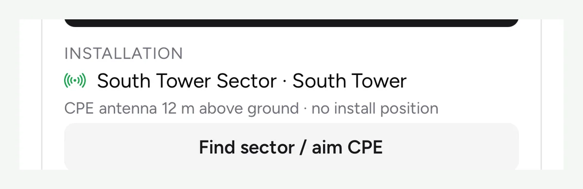
When the sector finder is opened from a service, an Assign to service button appears on each sector. It writes the chosen sector and the CPE antenna height onto the subscriber service; when the position came from the phone GPS, the app also offers to save it as the install location.
The same fields are on the service in the panel, under Network & Installation on the service edit page, so office staff can set or correct them without the app.
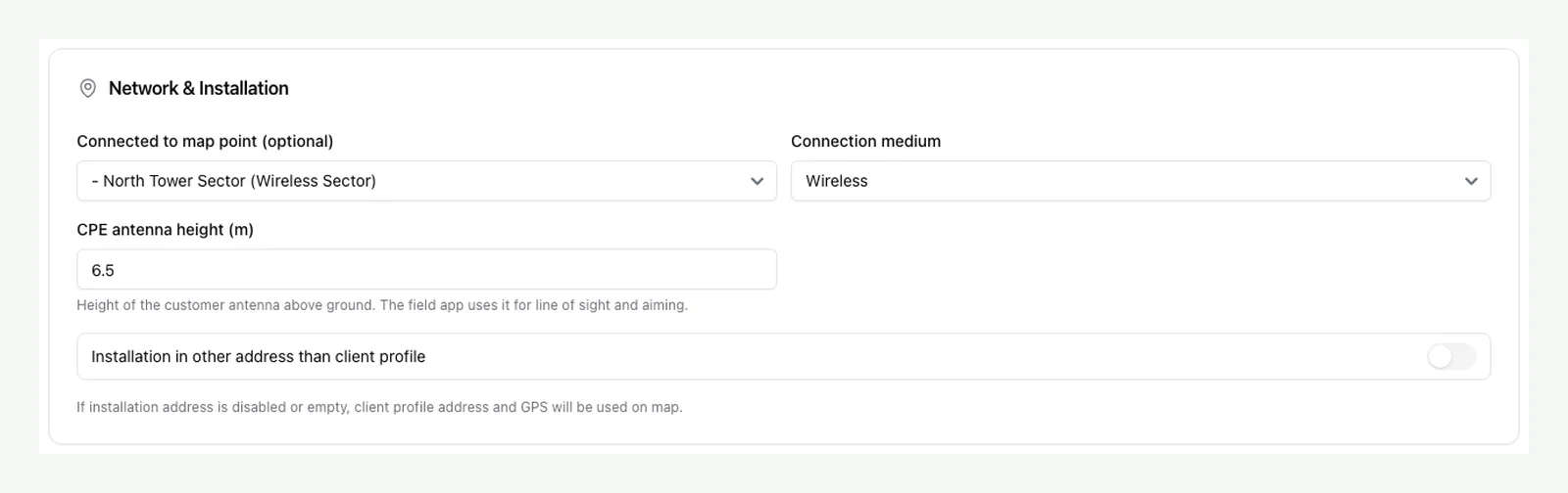
Keeping this filled in pays off later: support sees which sector a complaining subscriber is on, and the next technician on that roof starts from the real antenna height instead of guessing.
What the check does not do
- It does not see trees or buildings. The profile uses ground elevation, so it catches hills and ridges only. A clear result means the terrain allows the path, not that the path is free.
- It does not measure signal. Nothing here replaces the radio: the aim gets you onto the right sector quickly, the radio confirms it.
- It needs terrain data. Where elevation data is unavailable, rows show "LOS unknown" and the angles assume flat ground.
- It needs the sensors of a real phone. Compass and tilt guidance do not work in a simulator or on a device without a magnetometer.
Troubleshooting
- No sectors in the list - the tenant has no wireless sector features on the map yet, or they are all marked deprecated.
- Every row says "Off beam" - either you are behind the panels, or the azimuth values on the map do not match reality. Check a known-good install against the list.
- Distances look wrong - the sector is missing its mast position, so the app fell back to the first corner of the polygon. Set the origin by placing the sector from its mast.
- "Terrain data is unavailable" - the elevation source is not reachable or not configured; ranking still works, but the line-of-sight column cannot.